ILLINOIS — Forecasters are warning of a potential severe weather outbreak across Illinois and surrounding Midwest states on Wednesday, June 18, as models signal an organized storm system taking shape over the central U.S.
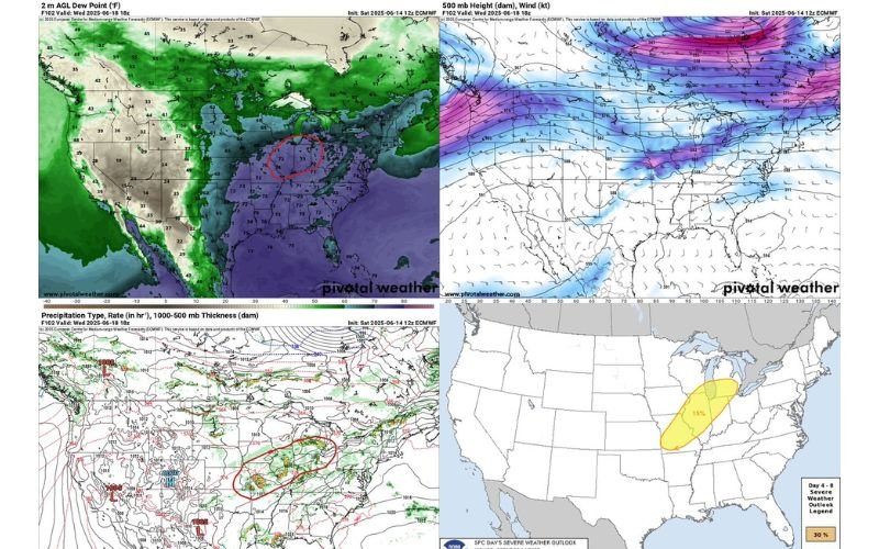
The Storm Prediction Center (SPC) has already issued a 15% severe weather risk for the region, which includes parts of Illinois, Missouri, Indiana, and neighboring states. This early designation places the area under a Day 5 outlook, which is uncommon and signals confidence in the potential for widespread damaging winds and storms.
View the SPC outlook map on NOAA’s official site.
Models Point to MCS Risk With High Dew Points
A look at mid- and upper-level weather models shows conditions supportive of a mesoscale convective system (MCS) — a long-lived storm complex capable of bringing strong winds, heavy rain, and localized hail.
-
Dew points across central Illinois are forecast to rise into the low to mid 70s°F, indicating extremely moist air that could help fuel thunderstorms.
-
500mb jet stream analysis shows a strong mid-level flow cutting across Missouri and Illinois, providing necessary lift.
-
Surface maps highlight convergence zones setting up near the Ohio Valley and Lower Midwest, with widespread precipitation signals.
Forecast snapshots from Pivotal Weather show energy building across eastern Missouri and central Illinois, supporting possible severe thunderstorm clusters by late Wednesday.
Timing and Track Still Developing
Meteorologists caution that exact timing and track remain uncertain, but all indications point to a corridor from central Missouri into central Illinois and Indiana as the primary threat zone. Rainfall models also suggest possible training storms, which could increase flash flood potential in some areas.
Current projections show the complex arriving in Illinois by Wednesday afternoon or evening, depending on how quickly the energy shifts from the Plains.
What Residents Should Watch For
The National Weather Service is expected to issue updated outlooks in the coming days. Meanwhile, residents across Illinois should prepare for:
-
High winds exceeding 60 mph
-
Large hail in isolated storms
-
Localized flooding in areas with repeated storm activity
-
Possible tornado risk, especially along the southern and eastern flanks of the MCS
Do you live in the risk zone for Wednesday’s storm potential?
Send your local forecasts, weather questions, or radar snapshots to ChicagoSuburbanFamily.com and help track the storm with our local community network.