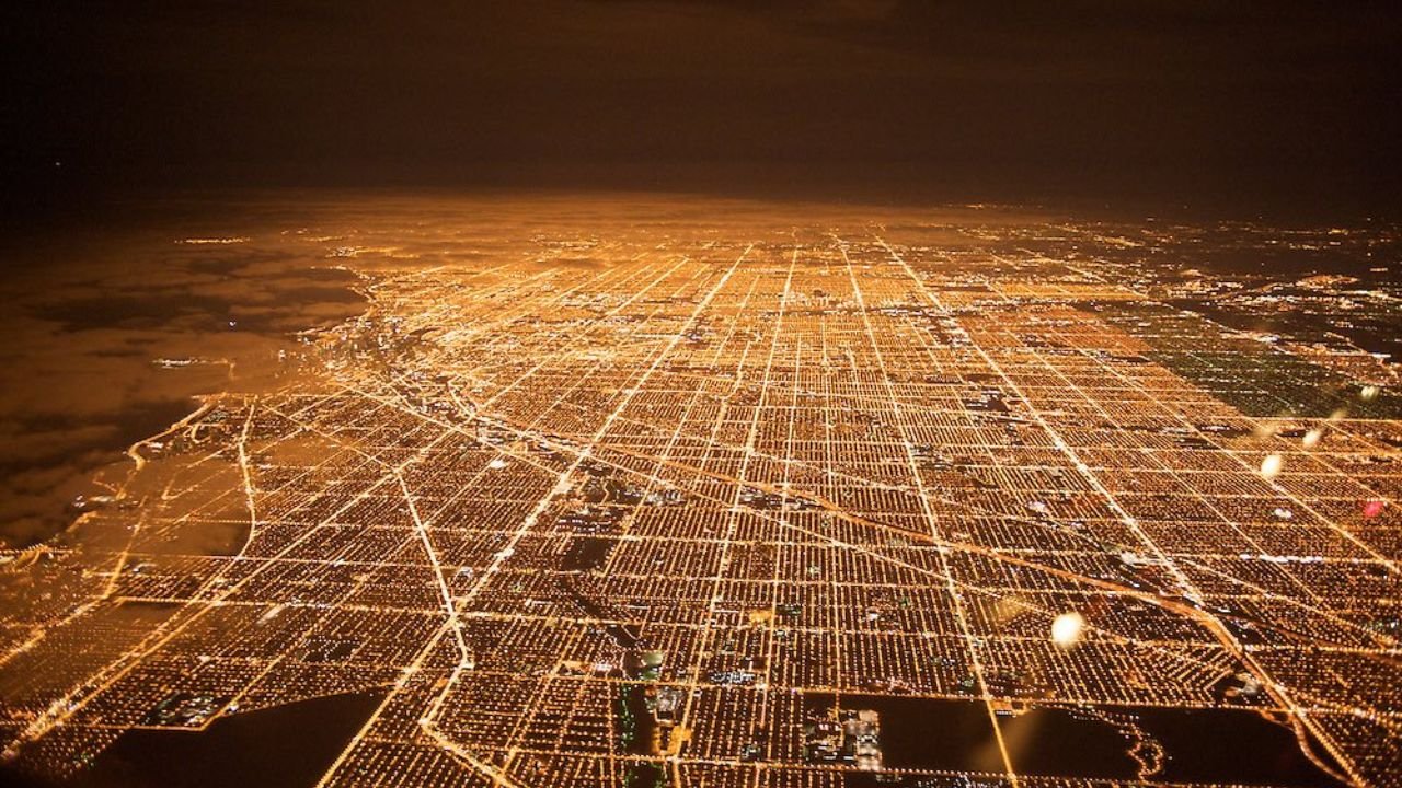
CHICAGO — A viral tweet comparing Chicago’s dazzling nighttime street grid to a “sheet of graph paper” has reignited public fascination with the city’s remarkable urban planning — and some heated debates about its origins.
The tweet, shared by user @north0fnorth, showcases two glowing aerial shots of Chicago’s streets lit up at night, highlighting the near-perfect symmetry of the grid system. The post has been viewed over 110,000 times, with many users expressing awe and curiosity about how Chicago came to look this way.
“It’s like someone dropped a glowing spreadsheet on the Earth,” one commenter joked.
But the real story of Chicago’s grid isn’t just about beauty — it’s about planning, disaster, and a city’s will to rise from the ashes.
The Truth About the Grid: Pre-Fire Planning
Many people believe the Great Chicago Fire of 1871 prompted the city to redesign itself in a more organized layout. But according to urban historians and Library of Congress archives, Chicago’s street grid was well underway even before the devastating blaze.
A historical map shared in the Twitter thread, published by The R.P. Studley Company shortly after the fire, clearly shows the grid system already in place across much of the city. In fact, the earliest components of the grid date back to 1830, when city planner James Thompson laid out Chicago’s original plat along the Chicago River. His plan emphasized perpendicular streets, regular blocks, and a standard lot size — foundational elements that still shape the city today.
“Chicago was gridded before the fire,” the poster clarified in a follow-up tweet, “as you can see from maps produced at the time.”
Why the Grid Works So Well in Chicago
Unlike older East Coast cities like Boston or New York — which evolved more organically and often chaotically — Chicago’s street plan was implemented at a time when the city could be shaped by choice rather than topography.
Thanks to its flat geography and swampy prairie terrain, the grid system was easy to implement and ideal for development. The 1909 Plan of Chicago by Daniel Burnham and Edward Bennett further reinforced the grid as a way to facilitate efficient transportation, commerce, and public access to lakefront parks.
Modern urbanists still point to Chicago as one of the most logically laid-out cities in the U.S. The city uses a numbering system with State and Madison Streets as central axes — making it easy to calculate how far north, south, east, or west you are.
For example: 800 North is roughly one mile north of Madison, while 2400 West is about three miles west of State.
The Nighttime Glow: Why It Looks So Symmetrical
When viewed from above, especially at night, the city’s lights follow its streets so precisely that it creates a grid of glowing orange and yellow lines stretching out into the horizon.
This is partially due to Chicago’s older sodium-vapor streetlights, which emit a warm amber glow. Newer neighborhoods and highways have started transitioning to LED lighting, but much of the iconic hue still remains. Combined with the flat topography and grid consistency, the visual effect is stunning — especially for those flying into O’Hare or Midway at night.
Not Just Aesthetic — It’s Functional
The grid’s orderliness also plays a major role in public safety, infrastructure maintenance, and transportation. Emergency response teams, delivery drivers, and public utility crews rely on Chicago’s numbered grid to navigate quickly.
Urban planner Pete Saunders has argued that Chicago’s grid is a democratic structure — a system that doesn’t favor winding cul-de-sacs or hidden lanes, but treats every block with equal weight. “It’s one of the most accessible cities for newcomers and locals alike,” Saunders wrote for The Urbanophile.
Have your own story about navigating Chicago’s iconic grid? Or a favorite nighttime view of the city? Share your thoughts at chicagosuburbanfamily.com — where we celebrate what makes this city beautifully structured.